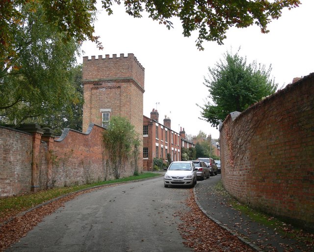
File:East Langton, Leicestershire - geograph.org.uk - 587829.jpg
- Documënt
- Storia dl documënt
- Coche l document ie stat adurvà
- Coche l documënt ie stat adurvà ntëur l mond
- Metadac
East_Langton,_Leicestershire_-_geograph.org.uk_-_587829.jpg (640 × 513 pixels, dimenjiun dl file: 130 KB, MIME type: image/jpeg)
Chësc documënt ven da Wikimedia Commons y po unì adurvà per autri proiec. Dessot ie la descrizion te la file description page.
Ressumé
| DescriziunEast Langton, Leicestershire - geograph.org.uk - 587829.jpg |
English: East Langton, Leicestershire The large castellated water tower belongs to East Langton Grange. Text from :
J M Lee and R A McKinley, 'Church Langton', in A History of the County of Leicestershire: Volume 5, Gartree Hundred (London, 1964), pp. 193-213. British History Online http://www.british-history.ac.uk/vch/leics/vol5/pp193-213 [accessed 15 February 2020].
|
| Data | |
| Funtana | From geograph.org.uk |
| Autur | Mat Fascione |
| Atribuzion (richiesto dalla licenza) InfoField | Mat Fascione / East Langton, Leicestershire / |
InfoField | Mat Fascione / East Langton, Leicestershire |
| Luogo dello scatto | 52° 31′ 34″ N, 0° 55′ 53″ W | Posizione di questa e altre immagini su: OpenStreetMap |
|---|
| Posizione del soggetto | 52° 31′ 34″ N, 0° 55′ 53″ W | Posizione di questa e altre immagini su: OpenStreetMap |
|---|
Lizënza

|
Questa immagine proviene dalla collezione del progetto Geograph. Vedi questa fotografia sul sito web di Geograph per visualizzare i dettagli relativi al fotografo. Il copyright di questa immagine appartiene a Mat Fascione ed è pubblicata secondo i termini della licenza Creative Commons Attribuzione-Condividi allo stesso modo 2.0.
|
- Tu ies liede:
- da spartì – per cupié, spartësc y manda l lëur
- da mudé – da adaté al lëur
- A chësta condizions:
- atribuzion – Tu mues atribué l lëur te la maniera che à spiegà l autëur o chël che à la lizënza (ma nia te na maniera che l smea che ëi te paiessa).
- fá na condivijiun tla medema manira – Sce te mudes o svilupeies chësc test, pudres mé spartì ora l lëur sota la medema lizënza o una che ti smea a chësta same or compatible license
- Remove redundant categories and try to put this image in the most specific category/categories
- Remove this template
- The location categories are based on information from this geonames tool and this OpenStreetMap tool combined with a database. You can also have a look at this tool from mysociety.
- The topic category from Geograph was Village (find similar images at Geograph)
English | suomi | français | galego | עברית | magyar | македонски | മലയാളം | português | português do Brasil | Türkçe | +/−
Didascalie
Elementi ritratti in questo file
raffigura italiano
creatore italiano
Valore sconosciuto senza un elemento Wikidata
stato del copyright italiano
coperto da diritti d'autore italiano
origine del file italiano
file disponibile su internet italiano
data di fondazione o creazione italiano
14 uto 2007
coordinate del punto di vista italiano
52°31'34.39"N, 0°55'53.40"W
immagine catturata con italiano
Panasonic Lumix DMC-FZ30 inglese
coordinate del luogo raffigurato italiano
52°31'34.39"N, 0°55'53.40"W
tempo di esposizione italiano
0,0125 secondo
rapporto focale italiano
4
lunghezza focale italiano
7,4 millimetro
sensibilità ISO italiano
80
istanza di italiano
fotografia italiano
tipo di file italiano
image/jpeg
geograph.org.uk image ID inglese
Storia dl documënt
Druca sun na data/ëura per udëi l documënt coche l fo te chël mumënt.
| Data/Ëura | Miniatura | Grandëza | utënt | Cumentar | |
|---|---|---|---|---|---|
| atuel | 14:38, 6 fau 2011 |  | 640 × 513 (130 KB) | GeographBot | == {{int:filedesc}} == {{Information |description={{en|1=East Langton, Leicestershire The large castellated water tower belongs to East Langton Grange.}} |date=2007-10-14 |source=From [http://www.geograph.org.uk/photo/587829 geograph.org.uk] |author=[http |
Coche l document ie stat adurvà
Chësta plata adroa chësc documënt:
Coche l documënt ie stat adurvà ntëur l mond
Ënghe chësta wikis adroa chësc documënt:
- Adurvà sun ceb.wikipedia.org
- Adurvà sun cy.wikipedia.org
- Adurvà sun en.wikipedia.org
- Adurvà sun fa.wikipedia.org
- Adurvà sun fr.wikipedia.org
- Adurvà sun pl.wikipedia.org
- Adurvà sun www.wikidata.org
Metadac
Te chësc file él informaziuns lapró, bonamënter injuntades dala fotocamera o dal scanner tuc ca por süa produziun o por le digitalisé. Sce le file é gnü mudé, podess n valgügn detais ne corespogn nia ala realté.
| Produttore fotocamera | Panasonic |
|---|---|
| Modello fotocamera | DMC-FZ30 |
| Tempo di esposizione | 1/80 s (0,0125) |
| Rapporto focale | f/4 |
| Sensibilità ISO | 80 |
| Data e ora di creazione dei dati | 14:07, 14 uto 2007 |
| Distanza focale obiettivo | 7,4 mm |
| Orientamento | Normale |
| Risoluzione orizzontale | 72 punti per pollice (dpi) |
| Risoluzione verticale | 72 punti per pollice (dpi) |
| Software | Ver.1.0 |
| Data e ora di modifica del file | 14:07, 14 uto 2007 |
| Posizionamento componenti Y e C | Co-situato |
| Programma di esposizione | Standard |
| Versione del formato Exif | 2.2 |
| Data e ora di digitalizzazione | 14:07, 14 uto 2007 |
| Modalità di compressione immagine | 4 |
| Correzione esposizione | 0 |
| Apertura massima | 3 APEX (f/2,83) |
| Metodo di misurazione | Pattern |
| Sorgente luminosa | Sconosciuta |
| Caratteristiche e stato del flash | Il flash non è scattato, rimozione flash forzato |
| Spazio dei colori | sRGB |
| Metodo di rilevazione | Sensore area colore a 1 chip |
| Elaborazione personalizzata | Processo normale |
| Modalità di esposizione | Esposizione automatica |
| Bilanciamento del bianco | Bilanciamento del bianco automatico |
| Rapporto zoom digitale | 0 |
| Focale equivalente su 35 mm | 35 mm |
| Tipo di acquisizione | Standard |
| Controllo contrasto | Normale |
| Controllo saturazione | Normale |
| Controllo nitidezza | Normale |
