File:Grand Canyon (1).jpg

Dimenjiuns de chësta odüda danfora:800 x 533 pixel. Autra resoluzions: 320 x 213 pixel | 640 x 427 pixel | 1 024 x 683 pixel | 1 280 x 853 pixel | 3 000 x 2 000 pixel.
Documënt uriginel (3 000 × 2 000 pixels, dimenjiun dl file: 2,64 MB, MIME type: image/jpeg)
.jpg)
Ressumé
| Descriziun |
Deutsch: Grand Canyon, Sicht vom Yavapai Point
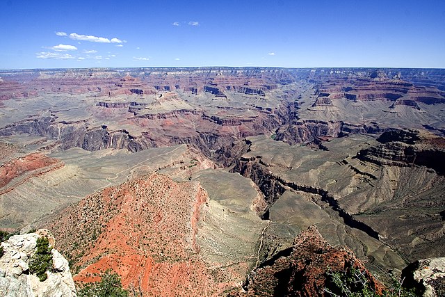
English: View from Yavapai Point. Brignt Angel Canyon, opposite Yavapai Point, (South Rim, view of Kaibab Plateau, North Rim). The thin, resistant en:Tapeats Sandstone forms the flatness in the inner canyon-(Tonto Platform), with the slope-forming units of Muav Limestone, and Bright Angel Shale accumulating upon it. The cliffs of the Redwall Limestone is one geologic layer above. (view slightly north-northwest) Isis Temple is the prominence in center. (Pipe Creek (canyon) is below on South Rim side). West of Isis Temple is Trinity Creek and its watershed canyon. Behind Isis Temple is the Phantom Creek, and watershed, with Buddha Temple and Buddha Cloister, just to the right (two points extend south to form Buddha Cloister -- Sturdevant Point, left, and Johnson Point (right over Bright Angel Canyon). (below, right, to Isis Temple) Cheops Pyramid (over whitish slopes). Isis Temple and Cheops Pyramid sit at the southwest fault block (a horst) at Bright Angel Canyon (and south wall of Phantom Creek (canyon)). The Grandview-Phantom faultline crosses, from NW to E-by-SE, (to Grandview Point-(South Rim), to turn, due-south). It intersects, here, at Granite Gorge with the Bright Angel Fault (NNE-by-SSW, approximate, north rim and south rim (up Indian Garden, Garden Creek)). The Unkar Group Horst which Isis and Cheops sit on has 3 sub-faults, as part of the horst-landform. The reddish and lavendar slopes at the promincence's base are Hakatai Shale, over Bsss Limestone. The Shinumo Quartzite forms the erosion-resistant cliff, above. (with no Tapeats Sandstone-(Tapeats Sea), the Shinumo was an island; instead, Bright Angel Shale, and Muav Limestone, above Note: Trinity Creek (watershed), left; Ninetyone Mile Creek wateshed (0.5 mi east); unnamed Wash, (drains Cheops Pyramid, on Unkar Group Horst), Wash = "Eightynine Mile Wash", and opposite outfall of Garden Creek (& Canyon, with en:Bright Angel Trail, from Maricopa Point region, South Rim); and Bright Angel Canyon (& Creek), photo right) |
| Data | 04/06 |
| Funtana | Opera personala |
| Autur | tom bernard anyz; Tenji at de.wikipedia |
Lizënza
Tenji da de.wikipedia.org, detentore del copyright su quest'opera, dichiara di pubblicarla con la seguente licenza:

|
AL é la lizënza da copié, da dé inant y/o müdé chësc documënt aladô dla lizënza GNU Free Documentation License, Verjiun 1.2 o vigni atra verjiun suandënta publicada dala Free Software Foundation; zënza seziuns che ara ne vá nia da mudé, zënza test söl cuertl ca dant y do ia. Na copia dla lizënza é tla seziun cun le titul Test dla GNU Free Documentation License. |
| Chësc file á la lizënza de destribuziun aladô dla lizënza Creative Commons Attribution-Share Alike 3.0 Unported. | ||
| Atribuzion: Tenji | ||
| ||
| Questo tag di copyright è stato aggiunto nell'ambito dell'aggiornamento della licenza dei progetti Wikimedia. |
Registro originale del caricamento
Transferred from de.wikipedia to Commons by Samoborac.
The original description page was here. All following user names refer to de.wikipedia.
- 2006-07-25 06:29 Tenji 3000×2000×8 (2763423 bytes) * Bildbeschreibung: grand canyon * Quelle: selbst fotografiert * Fotograf/Zeichner: tom bernard anyz * Datum: 04/06
| Annotations | This image is annotated: View the annotations at Commons |
[[Category:Bass Formation
Storia dl documënt
Druca sun na data/ëura per udëi l documënt coche l fo te chël mumënt.
| Data/Ëura | Miniatura | Grandëza | utënt | Cumentar | |
|---|---|---|---|---|---|
| atuel | 17:23, 10 mer 2008 | | 3 000 × 2 000 (2,64 MB) | File Upload Bot (Magnus Manske) | {{BotMoveToCommons|de.wikipedia}} {{Information |Description={{de|Grand canyon}} |Source=Transferred from [http://de.wikipedia.org de.wikipedia]; Transfer was stated to be made by User:Samoborac.<br/> (Original text : ''Selbst fotografiert'') |Date=0 |
Coche l document ie stat adurvà
Chësta plata adroa chësc documënt:
Coche l documënt ie stat adurvà ntëur l mond
Ënghe chësta wikis adroa chësc documënt:
- Adurvà sun arz.wikipedia.org
- Adurvà sun ceb.wikipedia.org
- Adurvà sun de.wikipedia.org
- Adurvà sun hr.wikipedia.org
- Adurvà sun pt.wikipedia.org
- Adurvà sun sh.wikipedia.org
- Adurvà sun sr.wikipedia.org
- Adurvà sun www.wikidata.org
.jpg)