File:Great Bavington village centre - geograph.org.uk - 1176848.jpg
Degöna resoluziun plü alta desponibla.
Great_Bavington_village_centre_-_geograph.org.uk_-_1176848.jpg (640 × 480 pixels, dimenjiun dl file: 83 KB, MIME type: image/jpeg)
Ressumé
| Descriziun |
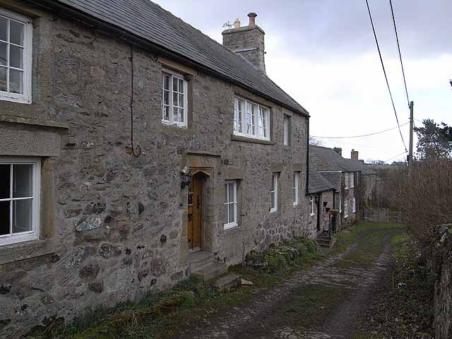
English: Great Bavington village centre These buildings stand at the very centre of Great Bavington which at one time was a much larger place than it is today. The house in the foreground is the oldest building still standing in the village and was built in 1625. The nearer part was once the "Harvest Home" public house, and subsequently the manse for the United Reformed Church across the way before being superseded by the new manse of 1854 adjacent to the Church.
The far end of the building housed the village school from 1855 until 1946. From 1949 the school building housed a Youth Hostel but it was closed in 1959 because of "unseemly behaviour" by the hostellers - what ever can that mean? The building is now divided into two private houses - Easter House (nearest the camera) and Easter Cottage. |
| Data | |
| Funtana | From geograph.org.uk |
| Autur | Oliver Dixon |
| Atribuzion (richiesto dalla licenza) | Oliver Dixon / Great Bavington village centre / |
| Luogo dello scatto | | Posizione di questa e altre immagini su: OpenStreetMap |
|---|
_heading:67.00&language=lld)
| Posizione del soggetto | | Posizione di questa e altre immagini su: OpenStreetMap |
|---|
_heading:67.00&language=lld)
Lizënza

|
Questa immagine proviene dalla collezione del progetto Geograph. Vedi questa fotografia sul sito web di Geograph per visualizzare i dettagli relativi al fotografo. Il copyright di questa immagine appartiene a Oliver Dixon ed è pubblicata secondo i termini della licenza Creative Commons Attribuzione-Condividi allo stesso modo 2.0.
|
Questo file è disponibile in base alla licenza Creative Commons Attribuzione-Condividi allo stesso modo 2.0 Generico
Atribuzion: Oliver Dixon
- Tu ies liede:
- da spartì – per cupié, spartësc y manda l lëur
- da mudé – da adaté al lëur
- A chësta condizions:
- atribuzion – Tu mues atribué l lëur te la maniera che à spiegà l autëur o chël che à la lizënza (ma nia te na maniera che l smea che ëi te paiessa).
- fá na condivijiun tla medema manira – Sce te mudes o svilupeies chësc test, pudres mé spartì ora l lëur sota la medema lizënza o una che ti smea a chësta same or compatible license
Storia dl documënt
Druca sun na data/ëura per udëi l documënt coche l fo te chël mumënt.
| Data/Ëura | Miniatura | Grandëza | utënt | Cumentar | |
|---|---|---|---|---|---|
| atuel | 19:27, 25 fau 2011 | | 640 × 480 (83 KB) | GeographBot | == {{int:filedesc}} == {{Information |description={{en|1=Great Bavington village centre These buildings stand at the very centre of Great Bavington which at one time was a much larger place than it is today. The house in the foreground is the oldest build |
Coche l document ie stat adurvà
Chësta plata adroa chësc documënt:
Coche l documënt ie stat adurvà ntëur l mond
Ënghe chësta wikis adroa chësc documënt: