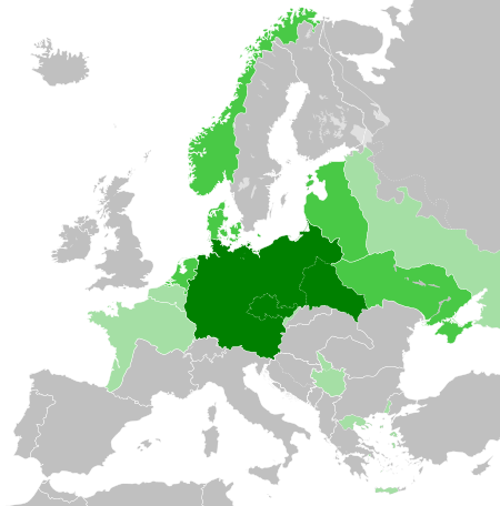
File:Greater German Reich (1942).svg

Dimensioni di questa anteprima PNG per questo file SVG: 450 x 456 pixel. Autra resoluzions: 237 x 240 pixel | 474 x 480 pixel | 758 x 768 pixel | 1 011 x 1 024 pixel | 2 021 x 2 048 pixel.
Documënt uriginel (file tl format SVG, dimenjiuns nominales 450 × 456 pixels, dimenjiun dl file: 594 KB)


.svg)
.svg)
.svg)
.svg)
.svg)


.svg)
.svg)
.svg)


.png)
.png)


.svg)


.svg)

.svg)


.svg)
.svg)
.svg)
.svg)


.svg)
.png)


.svg)


.svg)
.svg)


.svg)


.svg)


.svg)
.svg)
.svg)
.svg)
.svg)
.svg)
.svg)
.svg)
_cropped.svg)
.svg)
.svg)
.svg)
.svg)
.svg)
.svg)
.svg)
.svg)
.svg)
.svg)
.svg)
.svg)
.svg)
.svg)
.svg)
.svg)
.svg)
.svg)
.svg)
.svg)
.svg)
.svg)
.svg)
.svg)
.svg)
.svg)
.svg)
.svg)
.svg)
.svg)
.svg)
.svg)
.svg)
.svg)
.svg)
.svg)
.svg)
.svg)
.svg)
.svg)
.svg)
.svg)
.svg)
.svg)
.svg)
Storia dl documënt
Druca sun na data/ëura per udëi l documënt coche l fo te chël mumënt.
.svg&dir=prev)
.svg&offset=20180422235102)
.svg&offset=&limit=20)
.svg&offset=&limit=50)
.svg&offset=&limit=100)
.svg&offset=&limit=250)
.svg&offset=&limit=500)
| Data/Ëura | Miniatura | Grandëza | utënt | Cumentar | |
|---|---|---|---|---|---|
| atuel | 22:48, 20 mer 2023 | | 450 × 456 (594 KB) | Qbox673 | Reverted to version as of 07:51, 23 August 2020 (UTC) Please establish consensus on the talk page before changing. |
| 21:16, 19 mer 2023 |  | 450 × 456 (1,51 MB) | Daniilnihuya | Reverted to version as of 18:47, 22 August 2020 (UTC) | |
| 09:51, 23 ago 2020 |  | 450 × 456 (594 KB) | BOS2077 | Reverted to version as of 13:23, 28 July 2020 (UTC) | |
| 20:47, 22 ago 2020 |  | 450 × 456 (1,51 MB) | Terryfirut | Reverted to version as of 17:17, 5 July 2020 (UTC) | |
| 15:23, 28 lug 2020 |  | 450 × 456 (594 KB) | Staberinde | Reverted to version as of 01:04, 24 April 2018 (UTC) restore old version, puppet states are not the same thing as occupied territory | |
| 06:12, 7 lug 2020 |  | 450 × 456 (1,04 MB) | Croatianpotato | Reverted to version as of 22:35, 4 July 2020 (UTC) | |
| 19:17, 5 lug 2020 |  | 450 × 456 (1,51 MB) | Hell - lllio | Winter Offensive Occupied Territory | |
| 00:35, 5 lug 2020 |  | 450 × 456 (1,04 MB) | Hell - lllio | Vichy France (and its colonies) and Slovakia we're German Puppet States, so it should be Included in the Civilian Controlled Occupied Territories (Puppets) | |
| 03:04, 24 aur 2018 |  | 450 × 456 (594 KB) | TRAJAN 117 | +++ | |
| 01:51, 23 aur 2018 |  | 450 × 456 (594 KB) | TRAJAN 117 | +++ |
Coche l document ie stat adurvà
Chësta plata adroa chësc documënt:
Coche l documënt ie stat adurvà ntëur l mond
Ënghe chësta wikis adroa chësc documënt:
- Adurvà sun ar.wikipedia.org
- Adurvà sun av.wikipedia.org
- Adurvà sun az.wikipedia.org
- Adurvà sun bbc.wikipedia.org
- Adurvà sun bg.wikipedia.org
- Adurvà sun cs.wikipedia.org
- Adurvà sun el.wikipedia.org
- Adurvà sun en.wikipedia.org
- Adurvà sun es.wikipedia.org
- Adurvà sun fr.wikipedia.org
- Adurvà sun gn.wikipedia.org
- Adurvà sun he.wikipedia.org
- Adurvà sun hr.wikipedia.org
- Adurvà sun hu.wikipedia.org
- Adurvà sun id.wikipedia.org
- Jerman Nazi
- Daftar imperium terbesar
- Anschluss
- Wikipedia:Artikel pilihan/Jadwal/Usulan/2020
- Wikipedia:Artikel pilihan/Jadwal/Usulan/2020/Periode 3
- Wikipedia:Artikel pilihan/Jadwal/Usulan/2020/Periode 8
- Wikipedia:Artikel pilihan/Daftar artikel pilihan 2020
- Wikipedia:Artikel Pilihan/32 2020
- Wikipedia:Arsip halaman utama/2020/08/03
- Wikipedia:Arsip halaman utama/2020/08/04
- Wikipedia:Arsip halaman utama/2020/08/05
- Wikipedia:Arsip halaman utama/2020/08/06
- Wikipedia:Arsip halaman utama/2020/08/07
- Wikipedia:Arsip halaman utama/2020/08/08
- Wikipedia:Arsip halaman utama/2020/08/09
- Wikipedia:Artikel pilihan/Daftar artikel pilihan 2023
- Wikipedia:Artikel pilihan/Jadwal/Usulan/2023
Mostra utilisaziun globala de chësc file.
.svg)
.svg)