File:Illinois Traction System Minooka Passenger Station.jpg

Dimenjiuns de chësta odüda danfora:800 x 597 pixel. Autra resoluzions: 320 x 239 pixel | 640 x 478 pixel | 1 024 x 765 pixel | 1 280 x 956 pixel | 2 560 x 1 911 pixel | 4 721 x 3 525 pixel.
Documënt uriginel (4 721 × 3 525 pixels, dimenjiun dl file: 2,35 MB, MIME type: image/jpeg)
| Descriziun |
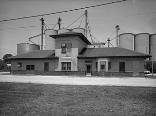
Illinois Traction System, Minooka Passenger Station, Minooka, Grundy County, IL. |
|||||||||||||||||||||||
| Data | ||||||||||||||||||||||||
| Funtana |
Historic American Buildings Survey HAER ILL, 32-MINK, 1-1
|
|||||||||||||||||||||||
| Autur |
|
|||||||||||||||||||||||
| Lizënza (Tó ca danü chësc file) |
|
|||||||||||||||||||||||

.jpg)
| Posizione del soggetto | | Posizione di questa e altre immagini su: OpenStreetMap |
|---|
Storia dl documënt
Druca sun na data/ëura per udëi l documënt coche l fo te chël mumënt.
| Data/Ëura | Miniatura | Grandëza | utënt | Cumentar | |
|---|---|---|---|---|---|
| atuel | 23:35, 12 aur 2008 | | 4 721 × 3 525 (2,35 MB) | Finavon | border cropped |
| 01:19, 31 mer 2007 |  | 5 000 × 4 013 (2,54 MB) | Dual Freq | {{Information |Description=Illinois Traction System, Minooka Passenger Station, Minooka, Grundy County, IL. (1. SOUTH FACADE OF STATION LOOKING NORTHWEST. HAER ILL, 32-MINK, 1-1) |Source=[http://memory.loc.gov/pnp/habshaer/il/il0600/il0650/photos/037235pu |
Coche l document ie stat adurvà
Chësta plata adroa chësc documënt:
Coche l documënt ie stat adurvà ntëur l mond
Ënghe chësta wikis adroa chësc documënt:
- Adurvà sun ar.wikipedia.org
- Adurvà sun ca.wikipedia.org
- Adurvà sun ceb.wikipedia.org
- Adurvà sun cy.wikipedia.org
- Adurvà sun en.wikipedia.org
- Adurvà sun es.wikipedia.org
- Adurvà sun eu.wikipedia.org
- Adurvà sun fr.wikipedia.org
- Adurvà sun glk.wikipedia.org
- Adurvà sun ht.wikipedia.org
- Adurvà sun it.wikipedia.org
- Adurvà sun mzn.wikipedia.org
- Adurvà sun pl.wikipedia.org
- Adurvà sun pt.wikipedia.org
- Adurvà sun sh.wikipedia.org
- Adurvà sun sr.wikipedia.org
- Adurvà sun uk.wikipedia.org
- Adurvà sun vi.wikipedia.org
- Adurvà sun www.wikidata.org
- Adurvà sun zh-min-nan.wikipedia.org
- Adurvà sun zh.wikipedia.org