File:Karnataka locator map.svg
Documënt uriginel(file tl format SVG, dimenjiuns nominales 1 630 × 2 356 pixels, dimenjiun dl file: 235 KB)

Chësc documënt ven da Wikimedia Commons y po unì adurvà per autri proiec. Dessot ie la descrizion te la file description page.

Titolo
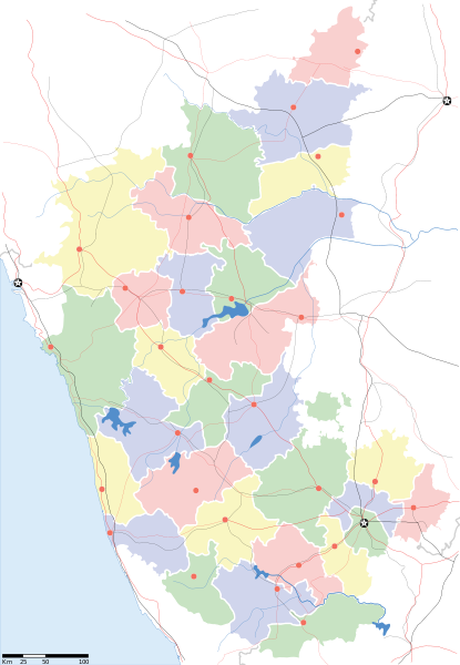
Karnataka locator Map
Descrizione
Map of w:Karnataka with road and rail lines
Data
Funtana

Opera personala
International Borders: University of Texas map library - India Political map 2001
Disputed Borders: University of Texas map library - China-India Borders - Eastern Sector 1988 & Western Sector 1988 - Kashmir Region 2004 - Kashmir Maps.
State and District boundaries: Census of India - 2001 Census State Maps - Survey of India Maps.
Other sources: US Army Map Service, Survey of India Map Explorer, Columbia University

Map specific sources: Karnataka Map, South Western Railway Map.
Creatore

যে নষ্ট

This Image was created by User:PlaneMad.
  • If you are using the image under the creative commons share alike license please credit the photo CC-by-sa PlaneMad/Wikimedia and include a link to this page. No explicit permission is needed from me, but id appreciate an email if my work has been of help to you.
  • If you dont want to release your work under a creative commons license, please mail me at arun.planemad@gmail.com or catch me at my Website to negotiate a custom license as per your needs.
Lizënza
(Tó ca danü chësc file)
Io, detentore del copyright su quest'opera, dichiaro di pubblicarla con la seguente licenza:
w:it:Creative Commons
atribuzion fá na condivijiun tla medema manira
Chësc file á la lizënza de destribuziun aladô dla lizënza Creative Commons Attribution-Share Alike 3.0 Unported.
Tu ies liede:
  • da spartì – per cupié, spartësc y manda l lëur
  • da mudé – da adaté al lëur
A chësta condizions:
  • atribuzion – Tu mues atribué l lëur te la maniera che à spiegà l autëur o chël che à la lizënza (ma nia te na maniera che l smea che ëi te paiessa).
  • fá na condivijiun tla medema manira – Sce te mudes o svilupeies chësc test, pudres mé spartì ora l lëur sota la medema lizënza o una che ti smea a chësta same or compatible license

The frontiers depicted on the Indian maps in Wikipedia are from a neutral point of view and may differ from official government maps of India, Pakistan and China. Please consult local laws governing publication of maps before usage.
 Geotemporal data
Data rappresentata seconda metà del XX sec. e XXI sec.
Georeferencing Georeference the map in Wikimaps Warper If inappropriate please set warp_status = skip to hide.
 Archival data
Note Part of WikiProject India Maps


derivative works

Derivative works of this file:  India Karnataka location map.svg

Didascalie

Aggiungi una brevissima spiegazione di ciò che questo file rappresenta

Elementi ritratti in questo file

raffigura italiano

Storia dl documënt

Druca sun na data/ëura per udëi l documënt coche l fo te chël mumënt.

Data/ËuraMiniaturaGrandëzautëntCumentar
atuel12:48, 20 nuë 2010Miniatura de la version de la 12:48, 20 nuë 20101 630 × 2 356 (235 KB)NayvikCreated 3 new districts Chikballapur district, Ramanagara district and Yadgir district
12:07, 8 mei 2007Miniatura de la version de la 12:07, 8 mei 20071 630 × 2 356 (226 KB)Planemadchg color of chamarajanagar
15:55, 6 mei 2007Miniatura de la version de la 15:55, 6 mei 20071 630 × 2 356 (226 KB)Planemad{{WikiProject_India_Maps |Title=Karnataka locator Map |Description=Map of w:Karnataka with road and rail lines |Source= [http://aquarium.lipetsk.ru/discovery/India2004/karnataka-map.jpg Karnataka Map], [http://www.indianrailways.gov.in/maps/st-wt-rly.

L ne da deguna plates che adroa chësc documënt.

Coche l documënt ie stat adurvà ntëur l mond

Ënghe chësta wikis adroa chësc documënt:

Mostra utilisaziun globala de chësc file.

Metadac