File:Madhhab Map2.png
Dimenjiuns de chësta odüda danfora:800 x 388 pixel. Autra resoluzions: 320 x 155 pixel | 640 x 310 pixel | 1 245 x 604 pixel.
Documënt uriginel (1 245 × 604 pixels, dimenjiun dl file: 50 KB, MIME type: image/png)

|
Questa immagine (categorizzazione automatica: religion map) o tutte le immagini in questa categoria o galleria dovrebbero essere ricreate usando grafica vettoriale come file SVG. Questo offre diversi vantaggi: vedi Commons:Media for cleanup per maggiori informazioni. Se è disponibile una versione in formato SVG di questa immagine, per favore caricala. Dopo aver caricato un file SVG, sostituisci questo avviso con il template {{Vector version available|nome_immagine.svg}}.
|
Ressumé
| Descriziun |
العربية: المدارس الفقهية الإسلامية الرئيسيّة وانتشارها حول العالم (لغة إنجليزية)
فارسی: نقشهٔ پراکندگی مذاهب فقهی اسلام در جهان (انگلیسی)
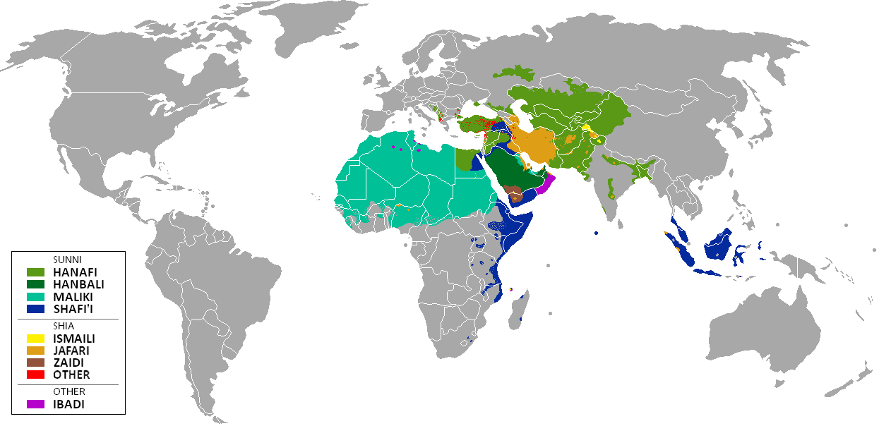
English: The distribution of the predominant Islamic madhhab (school of law) followed in majority-Muslim countries and regions (English)
Bahasa Indonesia: Distribusi penyebaran agama islam berdasarkan Mahdab di negara-negara dan wilayah dunia |
| Data | |
| Funtana | Own work by uploader from a blank-map, based on this source: Legal Sources and various other sources |
| Autur | Ghibar |
| Altre versioni |
Derivative works of this file: |
Lizënza
Io, detentore del copyright su quest'opera, dichiaro di pubblicarla con le seguenti licenze:
Chësc file á la lizënza de destribuziun aladô dla lizënza Creative Commons Attribution-Share Alike 3.0 Unported.
- Tu ies liede:
- da spartì – per cupié, spartësc y manda l lëur
- da mudé – da adaté al lëur
- A chësta condizions:
- atribuzion – Tu mues atribué l lëur te la maniera che à spiegà l autëur o chël che à la lizënza (ma nia te na maniera che l smea che ëi te paiessa).
- fá na condivijiun tla medema manira – Sce te mudes o svilupeies chësc test, pudres mé spartì ora l lëur sota la medema lizënza o una che ti smea a chësta same or compatible license

|
AL é la lizënza da copié, da dé inant y/o müdé chësc documënt aladô dla lizënza GNU Free Documentation License, Verjiun 1.2 o vigni atra verjiun suandënta publicada dala Free Software Foundation; zënza seziuns che ara ne vá nia da mudé, zënza test söl cuertl ca dant y do ia. Na copia dla lizënza é tla seziun cun le titul Test dla GNU Free Documentation License. |
Pos chirí fora la lizënza che as plü ion
| Annotations | This image is annotated: View the annotations at Commons |
Storia dl documënt
Druca sun na data/ëura per udëi l documënt coche l fo te chël mumënt.
| Data/Ëura | Miniatura | Grandëza | utënt | Cumentar | |
|---|---|---|---|---|---|
| atuel | 13:24, 23 jen 2018 | | 1 245 × 604 (50 KB) | Maphobbyist | Revert. Jafari school more widespread in northern Sumatra according to sources, than mere dots. |
| 13:55, 30 mei 2016 |  | 1 245 × 604 (2,87 MB) | Riyantojayadi | Madhhab majority of Aceh region[1] and West Sumatra/Minangkabau region[2] in Indonesia are Syafii school of Sunni. There are some tribe's ritual in this area that are based on Shia such tabot, however, for religion, they are practicing . Shia communiti... | |
| 15:45, 11 jen 2015 |  | 1 245 × 604 (50 KB) | AnonMoos | Reverted to version as of 02:11, 30 July 2014 -- see User_talk:Peaceworld111 | |
| 12:24, 11 jen 2015 |  | 1 245 × 604 (52 KB) | Peaceworld111 | Re-added Ahmadi. It's a sect of Islam per reliable sources and is not a mere dot. See talk page. | |
| 04:10, 11 jen 2015 |  | 1 245 × 604 (50 KB) | AnonMoos | Reverted to version as of 02:11, 30 July 2014 -- change not discussed on image talk page, possibly problematic, see user talk page | |
| 20:11, 8 jen 2015 |  | 1 245 × 604 (52 KB) | Peaceworld111 | Added Ahmadi | |
| 04:11, 30 lug 2014 |  | 1 245 × 604 (50 KB) | KronosLine | Fixed Russia | |
| 20:36, 20 lug 2014 |  | 1 245 × 604 (63 KB) | Calthinus | distribution of Bektashis in Albania fixed, distribution of Muslims in Greece & Macedonia (esp the ethnic Slav Macedonian Muslims, whose distribution had previously not been marked) fixed, various other fixes... | |
| 19:50, 19 uto 2013 |  | 1 245 × 604 (50 KB) | Hibernian | Damn it, that revert button doesn't do what I thought it does. Here's what I meant to change it to. This version also changes the Kerala Muslims to Shafi'i as was suggested on the talk page. | |
| 19:37, 19 uto 2013 |  | 1 245 × 604 (55 KB) | Hibernian | Reverted to previous version. It is totally illogical to not show the borders of states with limited recognition (practically every map on Wikipedia depicts these entities), it has nothing to do with the official UN definitions, but with showing reality. |
Coche l document ie stat adurvà
L ne da deguna plates che adroa chësc documënt.
Coche l documënt ie stat adurvà ntëur l mond
Ënghe chësta wikis adroa chësc documënt:
- Adurvà sun bn.wikipedia.org
- Adurvà sun bn.wikivoyage.org
- Adurvà sun en.wikipedia.org
- Adurvà sun en.wikivoyage.org
- Adurvà sun he.wikipedia.org
- Adurvà sun hi.wikivoyage.org
- Adurvà sun id.wikipedia.org
- Adurvà sun incubator.wikimedia.org
- Adurvà sun it.wikivoyage.org
- Adurvà sun ja.wikipedia.org
- Adurvà sun mzn.wikipedia.org
- Adurvà sun uk.wikipedia.org