File:Mount Hillers at the core of the Henry Mountains in Utah.jpg

Documënt uriginel (6 595 × 2 673 pixels, dimenjiun dl file: 2,57 MB, MIME type: image/jpeg)
Ressumé
| Descriziun |
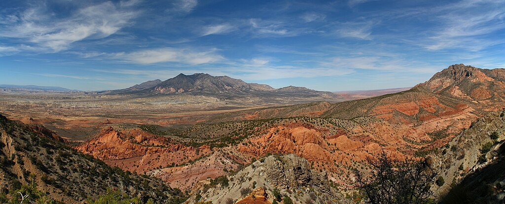
English: Mount Hillers at the core of the Henry Mountains in Utah.
In 1877 the USGS published a report "On the Geology of the Henry Mountains", on the small range of peaks in southern Utah. Up to that point, little scientific study had been made of the unassuming peaks, but the author of the report, one Grove Karl Gilbert, not only detailed the structure and mineralogy of the landscape, but in doing so also laid the foundations for much of modern geomorphology. While beautiful, the range is isolated and of limited economic value; Gilbert himself notably wrote that "No one but a geologist will ever profitably seek out the Henry Mountains", while the name given to the range by the Navajo is Dził Bizhiʼ Ádiní, literally meaning “mountain whose name is missing”. And yet, the wildness of the range is sufficient attraction for some - this is Mt Hillers, at the centre of the 5 peak range. Credit: Robert Emberson (distributed via imaggeo.egu.eu). |
| Data | |
| Funtana | https://imaggeo.egu.eu/view/13571/ |
| Autur | Robert Emberson (https://imaggeo.egu.eu/user/remberson/) |
| Luogo dello scatto | | Posizione di questa e altre immagini su: OpenStreetMap |
|---|
Lizënza
- Tu ies liede:
- da spartì – per cupié, spartësc y manda l lëur
- da mudé – da adaté al lëur
- A chësta condizions:
- atribuzion – Tu mues atribué l lëur te la maniera che à spiegà l autëur o chël che à la lizënza (ma nia te na maniera che l smea che ëi te paiessa).
Il presente file, originariamente pubblicato su https://imaggeo.egu.eu/view/13571/, in data 13 ottobre 2018 fu esaminato dall’amministratore o dal revisore Leoboudv, il quale conferma che alla data suddetta l’immagine era disponibile a tale URL sotto la licenza citata.
|
| Annotations | This image is annotated: View the annotations at Commons |
Storia dl documënt
Druca sun na data/ëura per udëi l documënt coche l fo te chël mumënt.
| Data/Ëura | Miniatura | Grandëza | utënt | Cumentar | |
|---|---|---|---|---|---|
| atuel | 23:55, 13 uto 2018 | 6 595 × 2 673 (2,57 MB) | GeoWriter | User created page with UploadWizard |
Coche l document ie stat adurvà
Chësta plata adroa chësc documënt:
Coche l documënt ie stat adurvà ntëur l mond
Ënghe chësta wikis adroa chësc documënt:
- Adurvà sun arz.wikipedia.org
- Adurvà sun ca.wikipedia.org
- Adurvà sun ceb.wikipedia.org
- Adurvà sun en.wikipedia.org
- Adurvà sun www.wikidata.org