File:New Mexico bootheel topo v1.jpg

Dimenjiuns de chësta odüda danfora:728 x 600 pixel. Autra resoluzions: 292 x 240 pixel | 583 x 480 pixel | 933 x 768 pixel | 1 139 x 938 pixel.
Documënt uriginel (1 139 × 938 pixels, dimenjiun dl file: 355 KB, MIME type: image/jpeg)
Ressumé
| Descriziun |
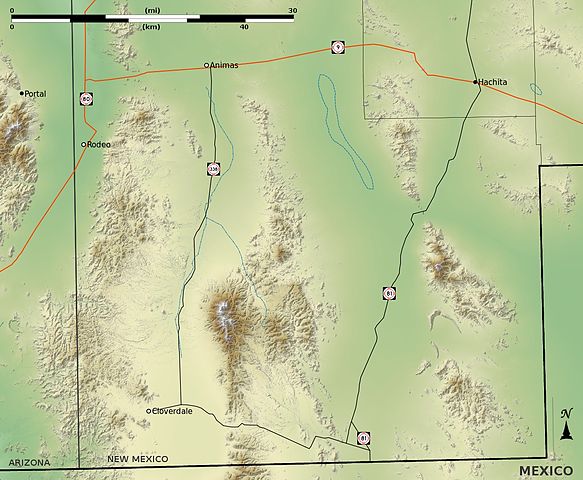
English: A shaded-relief topo map of the New Mexico Bootheel region, located in southern Hidalgo County, southwestern New Mexico.
|
| Data | |
| Funtana | Opera personala using data from the USGS Seamless Data Server.[1] |
| Autur | Kbh3rd |
This map projected in UTM zone 12 North (WGS 84): EPSG #32612.[2] In that coordinate system the location and extent of this map is described by this world file:
- 87.602971263452105
- 0
- 0
- -87.602971263452105
- 672005.79337163176
- 3548314.6479514274
In geographic coordinates the map is at:
- Upper Left: 109° 10' 42.30" W; 32° 3' 30.18" N
- Lower Left: 109° 11' 34.21" W; 31° 19' 2.58" N
- Upper Right: 108° 7' 20.59" W; 32° 2' 19.68" N
- Lower Right: 108° 8' 42.52" W; 31° 17' 54.08" N
- Center: 108° 39' 34.76" W; 31° 40' 45.57" N
The north-south meridian in this map tilts approximately 0.88° to the left as an effect of the UTM coordinate system employed here.
Lizënza
Io, detentore del copyright su quest'opera, dichiaro di pubblicarla con le seguenti licenze:
Chësc file á la lizënza de destribuziun aladô dla lizënza Creative Commons Attribution-Share Alike 3.0 Unported.
- Tu ies liede:
- da spartì – per cupié, spartësc y manda l lëur
- da mudé – da adaté al lëur
- A chësta condizions:
- atribuzion – Tu mues atribué l lëur te la maniera che à spiegà l autëur o chël che à la lizënza (ma nia te na maniera che l smea che ëi te paiessa).
- fá na condivijiun tla medema manira – Sce te mudes o svilupeies chësc test, pudres mé spartì ora l lëur sota la medema lizënza o una che ti smea a chësta same or compatible license

|
AL é la lizënza da copié, da dé inant y/o müdé chësc documënt aladô dla lizënza GNU Free Documentation License, Verjiun 1.2 o vigni atra verjiun suandënta publicada dala Free Software Foundation; zënza seziuns che ara ne vá nia da mudé, zënza test söl cuertl ca dant y do ia. Na copia dla lizënza é tla seziun cun le titul Test dla GNU Free Documentation License. |
Pos chirí fora la lizënza che as plü ion
Storia dl documënt
Druca sun na data/ëura per udëi l documënt coche l fo te chël mumënt.
| Data/Ëura | Miniatura | Grandëza | utënt | Cumentar | |
|---|---|---|---|---|---|
| atuel | 18:46, 19 dez 2010 | | 1 139 × 938 (355 KB) | Kbh3rd | {{Information |Description={{en|1=A shaded-relief topo map of the area of the New Mexico bootheel.}} |Source={{own}} |Author=Kbh3rd |Date= |Permission= |other_version |
Coche l document ie stat adurvà
Chësta plata adroa chësc documënt:
Coche l documënt ie stat adurvà ntëur l mond
Ënghe chësta wikis adroa chësc documënt:
- Adurvà sun ceb.wikipedia.org
- Adurvà sun en.wikipedia.org
- Adurvà sun es.wikipedia.org
- Adurvà sun fy.wikipedia.org
- Adurvà sun it.wikipedia.org
- Adurvà sun www.wikidata.org