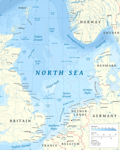
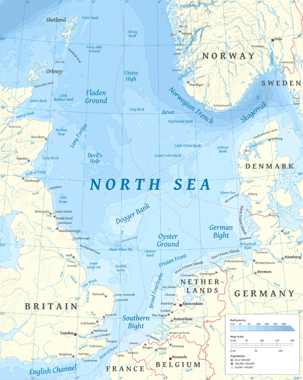
File:North Sea map-en.png

Dimenjiuns de chësta odüda danfora:479 x 600 pixel. Autra resoluzions: 192 x 240 pixel | 383 x 480 pixel | 613 x 768 pixel | 817 x 1 024 pixel | 2 475 x 3 100 pixel.
Documënt uriginel (2 475 × 3 100 pixels, dimenjiun dl file: 3,8 MB, MIME type: image/png)
P
Ressumé
| Descriziun | |
| Data | |
| Funtana |
Opera personala using en:GRASS GIS, en:Inkscape and en:GIMP. Data sources:
Map Projection: Universal Transverse Mercator Typeface: Gentium Book Basic from SIL International |
| Autur | Halava |
| Altre versioni |
  |
Lizënza
Io, detentore del copyright su quest'opera, dichiaro di pubblicarla con le seguenti licenze:
Chësc file á la lizënza de destribuziun aladô dla lizënza Creative Commons Attribution-Share Alike 3.0 Unported.
- Tu ies liede:
- da spartì – per cupié, spartësc y manda l lëur
- da mudé – da adaté al lëur
- A chësta condizions:
- atribuzion – Tu mues atribué l lëur te la maniera che à spiegà l autëur o chël che à la lizënza (ma nia te na maniera che l smea che ëi te paiessa).
- fá na condivijiun tla medema manira – Sce te mudes o svilupeies chësc test, pudres mé spartì ora l lëur sota la medema lizënza o una che ti smea a chësta same or compatible license

|
AL é la lizënza da copié, da dé inant y/o müdé chësc documënt aladô dla lizënza GNU Free Documentation License, Verjiun 1.2 o vigni atra verjiun suandënta publicada dala Free Software Foundation; zënza seziuns che ara ne vá nia da mudé, zënza test söl cuertl ca dant y do ia. Na copia dla lizënza é tla seziun cun le titul Test dla GNU Free Documentation License. |
Pos chirí fora la lizënza che as plü ion
| Annotations | This image is annotated: View the annotations at Commons |
Storia dl documënt
Druca sun na data/ëura per udëi l documënt coche l fo te chël mumënt.
| Data/Ëura | Miniatura | Grandëza | utënt | Cumentar | |
|---|---|---|---|---|---|
| atuel | 19:23, 5 mer 2015 | | 2 475 × 3 100 (3,8 MB) | Tandru7 | {{Information |Description=Map of the North Sea |Source=Wiki Commons |Date=3/5/15 |Author= |Permission= |other_versions= }} |
| 16:48, 15 uto 2010 |  | 2 475 × 3 100 (3,8 MB) | Halava | New place names | |
| 19:34, 12 uto 2010 |  | 2 475 × 3 100 (3,79 MB) | Halava | Some corrections; several new place names | |
| 13:02, 12 uto 2010 |  | 2 475 × 3 100 (3,78 MB) | Halava | Minor corrections; improved legibility; Horns Rev | |
| 10:09, 10 uto 2010 |  | 2 475 × 3 100 (3,72 MB) | Halava | Exclusive economic zones; Heligoland | |
| 11:26, 9 uto 2010 |  | 2 475 × 3 100 (3,64 MB) | Halava | Lindisfarne; Norfolk Banks instead of Wells Bank | |
| 22:27, 8 uto 2010 |  | 2 475 × 3 100 (3,63 MB) | Halava | Outlined Dogger Bank, fixed a typo | |
| 19:04, 8 uto 2010 |  | 2 475 × 3 100 (3,61 MB) | Halava | Several improvements | |
| 12:52, 6 uto 2010 |  | 2 475 × 3 100 (3,37 MB) | Halava | Fixed two typos, switched color model to RGB | |
| 12:09, 6 uto 2010 |  | 2 475 × 3 100 (2,57 MB) | Halava | {{Information |Description={{en|1=Map of the North Sea.}} |Source={{own}} using GRASS GIS, Inkscape and GIMP. Data sources: * Elevation and bathymetry data from NGDC ETOPO1 * Coastlines, rivers and borders from NGDC World Data Bank II * Cities from OpenS |
Coche l document ie stat adurvà
Chësta plata adroa chësc documënt:
Coche l documënt ie stat adurvà ntëur l mond
Ënghe chësta wikis adroa chësc documënt:
- Adurvà sun af.wikipedia.org
- Adurvà sun ar.wikipedia.org
- Adurvà sun arz.wikipedia.org
- Adurvà sun ast.wikipedia.org
- Adurvà sun ba.wikipedia.org
- Adurvà sun be-tarask.wikipedia.org
- Adurvà sun bg.wikipedia.org
- Adurvà sun br.wikipedia.org
- Adurvà sun ca.wikipedia.org
- Adurvà sun cs.wikipedia.org
- Adurvà sun cy.wikipedia.org
- Adurvà sun de.wikipedia.org
- Adurvà sun de.wikivoyage.org
- Adurvà sun el.wikipedia.org
- Adurvà sun en.wikipedia.org
- North Sea
- Skagerrak
- SMS Lützow
- HMS King Edward VII
- HMS Marlborough (1912)
- HMS Emperor of India
- HMS Africa (1905)
- Horns Rev
- HMS Britannia (1904)
- Silverpit crater
- Broad Fourteens
- Dogger Bank
- Long Forties
- HMS Hibernia (1905)
- Fisher Bank
- Norwegian trench
- Silver Pit
- Wikipedia:Userboxes/Location
- Operation Wikinger
- HMS Commonwealth
- Northern Patrol
- Raid on Scarborough, Hartlepool and Whitby
- HMS Hindustan (1903)
- User:Buaidh
- Southern Bight
- History of the North Sea
- First Ostend Raid
- Bombardment of Yarmouth and Lowestoft
Mostra utilisaziun globala de chësc file.