File:St Mark, Amcotts - geograph.org.uk - 423061.jpg
Degöna resoluziun plü alta desponibla.
St_Mark,_Amcotts_-_geograph.org.uk_-_423061.jpg (640 × 480 pixels, dimenjiun dl file: 70 KB, MIME type: image/jpeg)
Ressumé
| Descriziun |
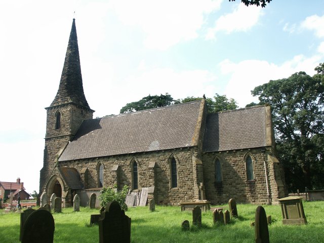
English: St Mark, Amcotts Standing near Flixborough and by the River Trent, the church of St Mark was built in the 1850s. The present building is the third to be built on the site. The foundation stone was laid on Tuesday 22nd October 1850 and was completed and dedicated to St Mark a year later, although the exact date is unknown. On 1st June 1974 the church was badly damaged with the Nypro explosion at Flixborough when the blast lifted the roof and dropped it again leaving a gap of 8 inches at the apex. The stained glass east window was completely blown in, there were cracks in the outer walls and it looked as though the church may have to be pulled down. Restoration did take place and although it also meant remaking the east window, the work was completed in two years. |
| Data | |
| Funtana | From geograph.org.uk |
| Autur | Dave Hitchborne |
| Atribuzion (richiesto dalla licenza) | Dave Hitchborne / St Mark, Amcotts / |
| Luogo dello scatto | | Posizione di questa e altre immagini su: OpenStreetMap |
|---|
_heading:315.00&language=lld)
| Posizione del soggetto | | Posizione di questa e altre immagini su: OpenStreetMap |
|---|
_heading:315.00&language=lld)
Lizënza

|
Questa immagine proviene dalla collezione del progetto Geograph. Vedi questa fotografia sul sito web di Geograph per visualizzare i dettagli relativi al fotografo. Il copyright di questa immagine appartiene a Dave Hitchborne ed è pubblicata secondo i termini della licenza Creative Commons Attribuzione-Condividi allo stesso modo 2.0.
|
Questo file è disponibile in base alla licenza Creative Commons Attribuzione-Condividi allo stesso modo 2.0 Generico
Atribuzion: Dave Hitchborne
- Tu ies liede:
- da spartì – per cupié, spartësc y manda l lëur
- da mudé – da adaté al lëur
- A chësta condizions:
- atribuzion – Tu mues atribué l lëur te la maniera che à spiegà l autëur o chël che à la lizënza (ma nia te na maniera che l smea che ëi te paiessa).
- fá na condivijiun tla medema manira – Sce te mudes o svilupeies chësc test, pudres mé spartì ora l lëur sota la medema lizënza o una che ti smea a chësta same or compatible license
Storia dl documënt
Druca sun na data/ëura per udëi l documënt coche l fo te chël mumënt.
| Data/Ëura | Miniatura | Grandëza | utënt | Cumentar | |
|---|---|---|---|---|---|
| atuel | 07:35, 4 fau 2011 | | 640 × 480 (70 KB) | GeographBot | == {{int:filedesc}} == {{Information |description={{en|1=St Mark, Amcotts Standing near Flixborough and by the River Trent, the church of St Mark was built in the 1850s. The present building is the third to be built on the site. The foundation stone was |
Coche l document ie stat adurvà
Chësta plata adroa chësc documënt:
Coche l documënt ie stat adurvà ntëur l mond
Ënghe chësta wikis adroa chësc documënt:
- Adurvà sun ceb.wikipedia.org
- Adurvà sun cy.wikipedia.org
- Adurvà sun en.wikipedia.org
- Adurvà sun fr.wikipedia.org
- Adurvà sun nl.wikipedia.org
- Adurvà sun pl.wikipedia.org
- Adurvà sun www.wikidata.org