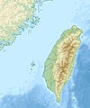
File:Taiwan relief location map.jpg

Dimenjiuns de chësta odüda danfora:498 x 599 pixel. Autra resoluzions: 199 x 240 pixel | 399 x 480 pixel | 1 016 x 1 222 pixel.
Documënt uriginel (1 016 × 1 222 pixels, dimenjiun dl file: 101 KB, MIME type: image/jpeg)
Storia dl documënt
Druca sun na data/ëura per udëi l documënt coche l fo te chël mumënt.
| Data/Ëura | Miniatura | Grandëza | utënt | Cumentar | |
|---|---|---|---|---|---|
| atuel | 16:01, 19 sët 2019 |  | 1 016 × 1 222 (101 KB) | Geographyinitiative | temporary fix: extending the boundary out around Dongyin Township (as in China Fujian2 location map.svg and as in File:Nationalist China - administrative divisons. LOC 2007633622.jpg) |
| 19:09, 3 ago 2019 |  | 1 016 × 1 222 (537 KB) | NordNordWest | border corrections | |
| 03:51, 3 ago 2019 |  | 1 016 × 1 222 (96 KB) | Geographyinitiative | Proposed removal of three dashes (markers of the approximate PRC/ROC maritime boundary) which seemed to put Dadan Island, Erdan Island and Binlang Islet (檳榔嶼) outside the territory of Kinmen County, Taiwan/ROC. This is not the optimal form of the map, but is merely a quick removal of incorrect information. In the optimal situation, the line needs to be redrawn in the correct location, but I don't have the technical skill to produce such a map. (Basis: [http://ws.mac.gov.tw/001/Upload/OldFile/... | |
| 02:30, 3 ago 2019 |  | 1 016 × 1 222 (96 KB) | Geographyinitiative | Proposed removal of two dashes (markers of the approximate PRC/ROC maritime boundary) which seemed to put {{w|Dadan Island}} and {{w|Erdan Island}} outside the territory of {{w|Kinmen County}}, Taiwan/ROC. | |
| 19:22, 28 dez 2010 |  | 1 016 × 1 222 (452 KB) | Uwe Dedering | {{Information |Description={{en|1=Relief location map of Taiwan. * Projection: Equirectangular projection, strechted by 110.0%. * Geographic limits of the map: :* N: 26.4° N :* S: 21.7° N :* W: 118.0° E :* E: 122.3° E * GMT projection: -JX17.204266666 |
Coche l document ie stat adurvà
Plü de 100 plates utilisëia chësc file. La lista suandënta mostra ma les prömes 100 plates che utilisëia chësc file. Al é dan man na lista globala.
- Baoshan (Hsinchu)
- Baozhong (Yunlin)
- Beidou (Changhua)
- Beigang (Yunlin)
- Beipu (Hsinchu)
- Budai (Chiayi)
- Caotun (Nantou)
- Citong (Yunlin)
- Dacheng (Changhua)
- Dacun (Changhua)
- Dahu (Miaoli)
- Dalin (Chiayi)
- Dapi (Yunlin)
- Datong (Yilan)
- Dongshan (Yilan)
- Dongshi (Yunlin)
- Dounan (Yunlin)
- Emei (Hsinchu)
- Erlin (Changhua)
- Erlun (Yunlin)
- Ershui (Changhua)
- Fangyuan (Changhua)
- Fenyuan (Changhua)
- Fuxing (Changhua)
- Gongguan (Miaoli)
- Guanxi (Hsinchu)
- Gukeng (Yunlin)
- Guoxing (Nantou)
- Hemei (Changhua)
- Hengshan (Hsinchu)
- Houlong (Miaoli)
- Huatan (Changhua)
- Hukou (Hsinchu)
- Huwei (Yunlin)
- Jianshi (Hsinchu)
- Jiaoxi (Yilan)
- Jiji (Nantou)
- Kouhu (Yunlin)
- Linnei (Yunlin)
- Lioujiao (Chiayi)
- Lugu (Nantou)
- Lukang (Changhua)
- Lunbei (Yunlin)
- Luodong (Yilan)
- Mailiao (Yunlin)
- Mingjian (Nantou)
- Minxiong (Chiayi)
- Nan'ao (Yilan)
- Nanzhuang (Miaoli)
- Pitou (Changhua)
- Puli (Nantou)
- Puxin (Changhua)
- Puyan (Changhua)
- Qionglin (Hsinchu)
- Ren'ai (Nantou)
- Sanwan (Miaoli)
- Sanxing (Yilan)
- Sanyi (Miaoli)
- Shengang (Changhua)
- Shetou (Changhua)
- Shitan (Miaoli)
- Shuili (Nantou)
- Shuilin (Yunlin)
- Sihu (Yunlin)
- Su'ao (Yilan)
- Tai'an (Miaoli)
- Taixi (Yunlin)
- Tianwei (Changhua)
- Tianzhong (Changhua)
- Tongluo (Miaoli)
- Tongxiao (Miaoli)
- Toucheng (Yilan)
- Touwu (Miaoli)
- Tuku (Yunlin)
- Wufeng (Hsinchu)
- Wujie (Yilan)
- Xianxi (Changhua)
- Xihu (Changhua)
- Xihu (Miaoli)
- Xikou (Chiayi)
- Xiluo (Yunlin)
- Xinfeng (Hsinchu)
- Xingang (Chiayi)
- Xinpu (Hsinchu)
- Xinyi (Nantou)
- Xiushui (Changhua)
- Xizhou (Changhua)
- Yongjing (Changhua)
- Yuanchang (Yunlin)
- Yuanli (Miaoli)
- Yuanshan (Yilan)
- Yuchi (Nantou)
- Zaoqiao (Miaoli)
- Zhongliao (Nantou)
- Zhuangwei (Yilan)
- Zhudong (Hsinchu)
- Zhunan (Miaoli)
- Zhuolan (Miaoli)
- Zhushan (Nantou)
- Zhutang (Changhua)
Visualizza altri collegamenti a questo file.
Coche l documënt ie stat adurvà ntëur l mond
Ënghe chësta wikis adroa chësc documënt:
- Adurvà sun ar.wikipedia.org
- Adurvà sun ast.wikipedia.org
- Adurvà sun az.wikipedia.org
- Adurvà sun ba.wikipedia.org
- Adurvà sun bcl.wikipedia.org
- Adurvà sun be.wikipedia.org
- Adurvà sun bn.wikipedia.org
- Adurvà sun bs.wikipedia.org
- Adurvà sun ceb.wikipedia.org
- Adurvà sun ce.wikipedia.org
- Adurvà sun ckb.wikipedia.org
- Adurvà sun de.wikipedia.org
- Adurvà sun de.wikivoyage.org
Mostra utilisaziun globala de chësc file.

