File:The ruined church of St Felix - geograph.org.uk - 1528057.jpg
Degöna resoluziun plü alta desponibla.
The_ruined_church_of_St_Felix_-_geograph.org.uk_-_1528057.jpg (640 × 543 pixels, dimenjiun dl file: 116 KB, MIME type: image/jpeg)
This is a photo of listed building number 1168733. |
Ressumé
| Descriziun |
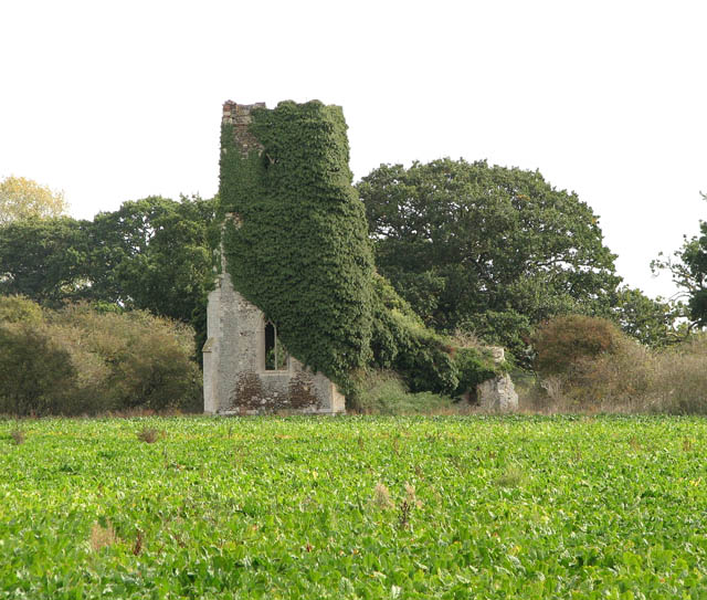
English: The ruined church of St Felix. The church of St Felix is situated on an overgrown island surrounded by a pasture and cultivated fields. The church once used to be adjoined by the now lost village of Babingley > 1528048. It fell into disrepair, perhaps due to its isolated location, and despite attempts to salvage what was left during the 19th century the building was soon abandoned for good. Closer to the main road (now the A149) the Chapel of St Felix > 1528028 was built as a replacement in the 1880s but it too fell into disuse and now serves the British Orthodox community. The ruin can be reached via a footpath and a gate > 1528045 which leads across a pasture. Much of what remains of the structure - the tower, porch and outer walls - is clad in vines of ivy and the churchyard is overgrown > 1528054. The nave, which at some stage was completely blocked off from the chancel by a still intact wall > 1528074 with a window in it (perhaps to be used for some other purpose for some time) is clear of vegetation and the south aisle arcade > 1528070 is still in place, as are two ornate wall recesses > 1528066 at the east end. Trees are growing in the chancel > 1528083 and there is a large gap in the north wall and where the east window used to be. Babingley is one of several locations claiming that the landfall of St Felix happened here (on the occasion of the saint's invitation by the Wuffings, the then East Anglian royal family). |
| Data | |
| Funtana | From geograph.org.uk |
| Autur | Evelyn Simak |
| Atribuzion (richiesto dalla licenza) | Evelyn Simak / The ruined church of St Felix / |
| Luogo dello scatto | | Posizione di questa e altre immagini su: OpenStreetMap |
|---|
_heading:90.00&language=lld)
| Posizione del soggetto | | Posizione di questa e altre immagini su: OpenStreetMap |
|---|
_heading:90.00&language=lld)
Lizënza

|
Questa immagine proviene dalla collezione del progetto Geograph. Vedi questa fotografia sul sito web di Geograph per visualizzare i dettagli relativi al fotografo. Il copyright di questa immagine appartiene a Evelyn Simak ed è pubblicata secondo i termini della licenza Creative Commons Attribuzione-Condividi allo stesso modo 2.0.
|
Questo file è disponibile in base alla licenza Creative Commons Attribuzione-Condividi allo stesso modo 2.0 Generico
Atribuzion: Evelyn Simak
- Tu ies liede:
- da spartì – per cupié, spartësc y manda l lëur
- da mudé – da adaté al lëur
- A chësta condizions:
- atribuzion – Tu mues atribué l lëur te la maniera che à spiegà l autëur o chël che à la lizënza (ma nia te na maniera che l smea che ëi te paiessa).
- fá na condivijiun tla medema manira – Sce te mudes o svilupeies chësc test, pudres mé spartì ora l lëur sota la medema lizënza o una che ti smea a chësta same or compatible license
Storia dl documënt
Druca sun na data/ëura per udëi l documënt coche l fo te chël mumënt.
| Data/Ëura | Miniatura | Grandëza | utënt | Cumentar | |
|---|---|---|---|---|---|
| atuel | 06:38, 3 mer 2011 | | 640 × 543 (116 KB) | GeographBot | == {{int:filedesc}} == {{Information |description={{en|1=The ruined church of St Felix The church of St Felix is situated on an overgrown island surrounded by a pasture and cultivated fields. The church once used to be adjoined by the now lost village of |
Coche l document ie stat adurvà
Chësta plata adroa chësc documënt:
Coche l documënt ie stat adurvà ntëur l mond
Ënghe chësta wikis adroa chësc documënt:
- Adurvà sun en.wikipedia.org
- Adurvà sun fr.wikipedia.org
- Adurvà sun www.wikidata.org