File:Trinity-Old-Red-Schoolhouse.jpg
Degöna resoluziun plü alta desponibla.
Trinity-Old-Red-Schoolhouse.jpg (770 × 470 pixels, dimenjiun dl file: 61 KB, MIME type: image/jpeg)
|
Questa è un'immagine di un luogo o edificio che è elencato nel National Register of Historic Places negli Stati Uniti. Il suo numero di riferimento è [https://npgallery.nps.gov/AssetDetail/NRIS/5000865
. 5000865
.]. |
Ressumé
| Descriziun |
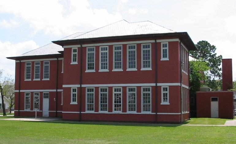
English: Old Red Schoolhouse. Trinity's first schoolhouse was a one-room log structure built in 1872 near Cedar Grove Cemetery. A two-story frame schoolhouse that stood on this site from 1897 to 1911 was moved several blocks northwest to serve African American students. Under Supt. J. Woolam Bright, construction of a new brick building began here in 1911, and after many delays it opened by 1915. The Prairie Style, T-Plan building housed all grade levels until completion of an adjacent High School in 1928. "Old Red" served as a schoolhouse for 80 years. When it was slated for demolition in the 1990s, concerned citizens and former students worked with the School District to preserve the historic building for continued use. Recorded Texas Historic Landmark - 2004. Listed in the National Register of Historic Places by the United States Department of the Interior. |
| Data | |
| Funtana | Own work by uploader Steven Driskell. |
| Autur | Steven L. Driskell (SDriskell) |
| Posizione del soggetto | | Posizione di questa e altre immagini su: OpenStreetMap |
|---|
Lizënza
Io, detentore del copyright su quest'opera, dichiaro di pubblicarla con le seguenti licenze:
Chësc file á la lizënza de destribuziun aladô dla lizënza Creative Commons Attribution-Share Alike 3.0 Unported.
- Tu ies liede:
- da spartì – per cupié, spartësc y manda l lëur
- da mudé – da adaté al lëur
- A chësta condizions:
- atribuzion – Tu mues atribué l lëur te la maniera che à spiegà l autëur o chël che à la lizënza (ma nia te na maniera che l smea che ëi te paiessa).
- fá na condivijiun tla medema manira – Sce te mudes o svilupeies chësc test, pudres mé spartì ora l lëur sota la medema lizënza o una che ti smea a chësta same or compatible license

|
AL é la lizënza da copié, da dé inant y/o müdé chësc documënt aladô dla lizënza GNU Free Documentation License, Verjiun 1.2 o vigni atra verjiun suandënta publicada dala Free Software Foundation; zënza seziuns che ara ne vá nia da mudé, zënza test söl cuertl ca dant y do ia. Na copia dla lizënza é tla seziun cun le titul Test dla GNU Free Documentation License. |
Pos chirí fora la lizënza che as plü ion
Storia dl documënt
Druca sun na data/ëura per udëi l documënt coche l fo te chël mumënt.
| Data/Ëura | Miniatura | Grandëza | utënt | Cumentar | |
|---|---|---|---|---|---|
| atuel | 22:07, 24 mer 2009 | | 770 × 470 (61 KB) | SDriskell | {{Information |Description={{en|1=Old Red Schoolhouse. Trinity's first schoolhouse was a one-room log structure built in 1872 near Cedar Grove Cemetery. A two-story frame schoolhouse that stood on this site from 1897 to 1911 was moved several blocks nor |
Coche l document ie stat adurvà
Chësta plata adroa chësc documënt:
Coche l documënt ie stat adurvà ntëur l mond
Ënghe chësta wikis adroa chësc documënt:
- Adurvà sun ar.wikipedia.org
- Adurvà sun arz.wikipedia.org
- Adurvà sun ceb.wikipedia.org
- Adurvà sun ce.wikipedia.org
- Adurvà sun cy.wikipedia.org
- Adurvà sun de.wikipedia.org
- Adurvà sun en.wikipedia.org
- Adurvà sun es.wikipedia.org
- Adurvà sun eu.wikipedia.org
- Adurvà sun ht.wikipedia.org
- Adurvà sun hu.wikipedia.org
- Adurvà sun it.wikipedia.org
- Adurvà sun no.wikipedia.org
- Adurvà sun pl.wikipedia.org
- Adurvà sun pt.wikipedia.org
- Adurvà sun sr.wikipedia.org
- Adurvà sun sv.wikipedia.org
- Adurvà sun tt.wikipedia.org
- Adurvà sun uz.wikipedia.org
- Adurvà sun vi.wikipedia.org
- Adurvà sun www.wikidata.org
- Adurvà sun zh-min-nan.wikipedia.org