File:Welcome to Bardney - geograph.org.uk - 1243832.jpg
Documënt uriginel (426 × 640 pixels, dimenjiun dl file: 93 KB, MIME type: image/jpeg)
Ressumé
| Descriziun |
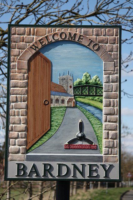
English: Welcome to Bardney, near to Bardney, Lincolnshire, Great Britain.
New Bardney village sign on Horncastle Road depicting Bardney Bridge <a title="https://www.geograph.org.uk/photo/517511" rel="nofollow" href="https://www.geograph.org.uk/photo/517511">Link</a><img style="padding-left:2px;" alt="External link" title="External link - shift click to open in new window" src="http://s0.geograph.org.uk/img/external.png" width="10" height="10"/> St.Lawrence's Church <a title="https://www.geograph.org.uk/photo/42589" rel="nofollow" href="https://www.geograph.org.uk/photo/42589">Link</a><img style="padding-left:2px;" alt="External link" title="External link - shift click to open in new window" src="http://s0.geograph.org.uk/img/external.png" width="10" height="10"/> and 9 Squadron Memorial <a title="https://www.geograph.org.uk/photo/954427" rel="nofollow" href="https://www.geograph.org.uk/photo/954427">Link</a><img style="padding-left:2px;" alt="External link" title="External link - shift click to open in new window" src="http://s0.geograph.org.uk/img/external.png" width="10" height="10"/> .... all viewed through an open door symbolising Bardney's most famous tale, recounted by the Venerable Bede |
| Data | |
| Funtana | From geograph.org.uk; transferred by User:LongLiveRock using geograph_org2commons. |
| Autur | Richard Croft |
| Lizënza (Tó ca danü chësc file) |
Creative Commons Attribution Share-alike license 2.0 |
| Luogo dello scatto | | Posizione di questa e altre immagini su: OpenStreetMap |
|---|
| Posizione del soggetto | | Posizione di questa e altre immagini su: OpenStreetMap |
|---|
_region:GB-GBN_heading:315.00&language=lld)
Lizënza

|
Questa immagine proviene dalla collezione del progetto Geograph. Vedi questa fotografia sul sito web di Geograph per visualizzare i dettagli relativi al fotografo. Il copyright di questa immagine appartiene a Richard Croft ed è pubblicata secondo i termini della licenza Creative Commons Attribuzione-Condividi allo stesso modo 2.0.
|
- Tu ies liede:
- da spartì – per cupié, spartësc y manda l lëur
- da mudé – da adaté al lëur
- A chësta condizions:
- atribuzion – Tu mues atribué l lëur te la maniera che à spiegà l autëur o chël che à la lizënza (ma nia te na maniera che l smea che ëi te paiessa).
- fá na condivijiun tla medema manira – Sce te mudes o svilupeies chësc test, pudres mé spartì ora l lëur sota la medema lizënza o una che ti smea a chësta same or compatible license
Storia dl documënt
Druca sun na data/ëura per udëi l documënt coche l fo te chël mumënt.
| Data/Ëura | Miniatura | Grandëza | utënt | Cumentar | |
|---|---|---|---|---|---|
| atuel | 01:34, 20 uto 2010 | | 426 × 640 (93 KB) | File Upload Bot (Magnus Manske) |
Coche l document ie stat adurvà
Chësta plata adroa chësc documënt:
Coche l documënt ie stat adurvà ntëur l mond
Ënghe chësta wikis adroa chësc documënt: